
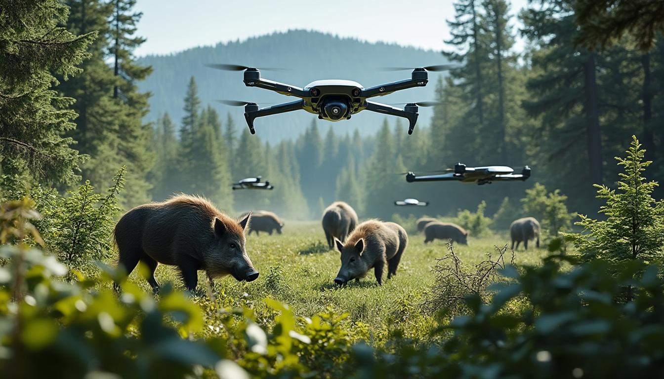
At night on the Alberta plains, a sounder of feral pigs can cross a field, cut through a wetland, and vanish into thick cover before anyone on the ground gets close. That slipperiness is exactly why the province has turned to AI-enhanced aerial surveillance. A recent Alberta-led project, built with university researchers, shows how drone technology, thermal cameras, and artificial intelligence can spot wild boar with far less disturbance than boots on the ground or low helicopter passes. For anyone tracking how governments are using innovative technology for pest control, wildlife management, and environmental protection, Alberta has become one of the most closely watched test cases in Canada.
Alberta Tests AI-Enhanced Drone Technology Against Wild Boar Invasion
The core idea is practical rather than flashy. Thermal drones flew in spring 2024, mostly at night, because warm-bodied animals stand out more sharply when the ground and vegetation cool down after sunset. Those flights fed video and image data into early-stage AI systems trained to recognize feral pigs and count them from the air.
Officials involved in the work described it as a new tool, not a silver bullet. That distinction matters. Alberta has spent years relying on public sightings, trail cameras, trapping efforts, and older reactive programs, including the well-known “Squeal on Pigs” reporting line. The problem is that wild pigs are smart, nocturnal, and quick to bolt into dense brush the moment they sense people nearby.
Looking down from above changes the equation. Researchers from Alberta Agriculture worked with the University of Calgary on what became the Wild Boar at Large Detection Project, and the provincial report published in late March framed automated thermal surveillance as a non-invasive option with real field promise. In plain terms, the animals don’t get pushed deeper into cover as easily, and crews can scan larger areas in less time.
Why Traditional Tracking Keeps Missing These Animals
Ground crews can follow prints and rooting damage, but those clues often go cold fast. Helicopter surveys cover distance, yet they’re expensive and noisy, and pigs tend to react before observers get a clean read. Trail cameras help, though they only show what passes in a narrow corridor.
Wild boar don’t behave like easy quarry. They move after dark, use heavy cover well, and travel in family groups called sounders, especially sows with piglets. A thermal drone can sweep over a broad area and catch the group pattern in one pass, which gives crews a better shot at planning traps or future surveillance.
That broad overhead view may be the most useful piece of the whole effort. Alberta isn’t dealing with a single rogue animal in one county. It’s facing an invasion pattern that stretches across farm country, wet ground, and shelterbelts, with hotspots near places such as Edmonton’s surrounding areas and Grande Prairie.
Video searches already reflect growing public interest in drone-based wildlife tracking, especially where thermal cameras meet AI image recognition.
Why Wild Boar Are Such A Serious Threat To Alberta Farms And Wetlands
These aren’t harmless escapees rooting around the edge of a pasture. Alberta’s feral population includes Eurasian wild boar and hybrids descended from domestic pigs and imported stock that got loose from farms. The hybrids are often called super pigs for a reason: they adapt fast, eat almost anything, and breed at a rate that turns a small problem into a regional one.
Most adults weigh roughly 55 to 115 kilograms, or about 120 to 250 pounds. Sows can produce two litters within 12 to 15 months, which means waiting too long is costly. A sounder that slips past detection one season can become a much bigger headache by the next.
The damage spreads in several directions at once. Crops get torn up. Wetlands are churned by wallowing. Livestock can be harassed. Water sources become contaminated. Then there’s disease risk, which is where the conversation gets more urgent for producers.
- Crop loss: rooting and trampling can wreck seeded fields and pasture edges in a single night.
- Habitat damage: wetlands and riparian areas suffer when pigs wallow and disturb soil.
- Livestock pressure: domestic animals can be stressed or exposed to disease pathways.
- Biosecurity risk: officials remain highly alert to threats such as African swine fever.
- Fast reproduction: rapid breeding makes delayed response expensive and messy.
African swine fever isn’t a minor side note. If it were detected in Alberta’s domestic pork sector, the economic fallout would be severe. That’s one reason the province has tightened restrictions on wild boar farming and banned sport hunting of these animals; casual pursuit can scatter groups and make organized eradication harder.
Honestly, the old bounty mindset always looked like the wrong fit for a species this wary. Science-led detection, coordinated trapping, and longer-term monitoring make more sense on open prairie and mixed farmland, especially around former boar farm zones.
What Makes Alberta’s Approach Different In 2026
By 2026, the province’s strategy is less reactive than it was a few years ago. Public reporting still matters, but the push now includes predictive mapping, better regulations, and targeted surveillance rather than waiting for repeated sightings after damage is already done.
That shift puts Alberta near the front of the Canadian pack. Researchers working on wild pig issues across the Prairies have said for years that no single detection method works on its own. Alberta seems to have accepted that reality and built a toolkit around it instead of chasing one perfect answer.
The numbers from the drone trials aren’t perfect, though they’re useful enough to change field decisions, especially in areas with water access and crop cover.
| Project element | What Alberta tested | Why it matters |
|---|---|---|
| Thermal drone flights | Night surveys using infrared sensors in spring conditions | Better contrast between animal heat and cooler surroundings |
| AI detection models | Two systems trained on aerial footage and partner datasets | Automates scanning and speeds up field analysis |
| Field coverage | More than 3,000 kilometres of drone work | Large search area across test sites and wild ranges |
| Detection performance | Over 75% accuracy in identifying herds | Strong early result for a hard-to-find species |
| Habitat mapping | Sightings layered with land and habitat data | Helps crews focus on likely hotspots |
How Drone Technology And Artificial Intelligence Were Trained In Real Alberta Conditions
One of the strongest parts of the project is that it wasn’t built only in a lab. Researchers used two boar operations in Alberta as testing grounds, which gave them controlled footage first and then tougher, more realistic conditions. One site in the Peace River area, about 390 kilometres northwest of Edmonton, supplied thermal images used to train and validate the models.
The second site, closer to Edmonton, added more natural cover. That mattered because real feral pigs don’t stand in open ground waiting to be identified. They cut through brush, shelterbelts, uneven terrain, and edge habitat where heat signatures can break up fast.
There was even a “spy pig” in the mix, a wild sow fitted with a GPS collar to help researchers locate active ranges in the field. It sounds like something from a prairie thriller, but it served a blunt purpose: find where pigs actually move, then test whether the airborne system could catch them there.
What The AI Models Got Right And Where They Still Struggled
Both image-recognition systems cleared the 75 percent accuracy mark when scanning herds. For a first-wave operational tool aimed at an elusive animal, that’s a strong result. It saves field crews time, trims down manual review, and helps standardize how sightings are recorded.
Still, the rough edges are obvious. Small piglets were harder to spot. In some clips, a whole cluster of animals could be mistaken for one larger body. Dense tree canopy sometimes blocked the heat signature entirely, while warm rocks or sun-heated branches created false cues.
Species confusion is another challenge. Deer, for example, can trigger uncertainty in thermal footage if angle, movement, and cover line up the wrong way. That’s why future training won’t just feed the system more pig imagery; it also needs stronger “not a pig” data pulled from other wildlife found across Alberta.
The next wave of work is likely to focus on better species separation, sharper performance in different terrain, and stronger use during disease-response scenarios, especially if officials ever need a quick count after a high-risk animal health alert.
Coverage of thermal and AI-based drone systems has widened well beyond agriculture, which helps explain why this Alberta trial is drawing attention outside Canada too.
Where Alberta Is Mapping Wild Boar Hotspots And What Comes Next For Wildlife Management
Detection is only half the story. The other half is prediction. Alongside the flight work, researchers built a habitat suitability map that combines public sightings with environmental clues, creating a clearer picture of where feral pigs are most likely to persist.
That model pointed toward likely trouble zones around Edmonton and Grande Prairie, though it remains a work in progress. Areas linked to current or former boar farms tend to matter because escaped animals and descendants often anchor there. Add water, grain fields, and cover, and the odds improve for long-term pig survival.
For wildlife management teams, this kind of mapping is more than a nice graphic on a government website. It tells crews where to place effort first. Traps, field verification, follow-up flights, and landowner outreach cost time and money. If Alberta can rank risk by habitat and history, it can act earlier and with less waste.
There’s a wider prairie lesson here too. Wild pigs don’t respect provincial borders, and researchers have been blunt about eradication taking years, probably decades, across Canada. Alberta’s current push still stands out because it ties together surveillance, regulation, agricultural risk, and environmental protection instead of treating them as separate files.
Anyone watching rural policy closely should keep an eye on how this system expands: more species training data, stronger digital mapping, and tighter integration with on-the-ground removal teams. If the province keeps that pace, the next test won’t be whether the drones can find pigs at night. It’ll be whether the response crews can get to the hotspot before the sounder reaches the next wetland east of Grande Prairie.